May 30 - 2018 The Dalles, Oregon

We are staying at a nice State Park right on the Columbia River, a few miles west of The Dalles.
This stop did not include any “must see” things, so we went out to explore the area.
Since our move here was a short one, we had time Tuesday (May 29) to visit the nearby town of The Dalles. A nice city of 12000 people, with a main street that is kept in an old style (reminded a little bit of the picture you have in your mind of a town on Route 66). But it is also noticeable that it, as many other towns of that size, is having problems keeping up the standard.We also found a nice place to eat there, celebrating Mary’s birthday, which was Tuesday.

The city is full of history. From the native Americans, who used it as a trading post; to Lewis and Clark, who stopped here for the winter on their exploration of the Louisiana Territory; to the place where the pioneers had to make a big decision on their westward trip on the Oregon Trail. We found some interesting murals (vægmalerier) on several buildings.
One was about the Oregon Trail. We have been meaning to find out more about it, and here we ran into  it again (we had also crossed it in Wyoming) - this time near the end of the 2000 mile (ca. 3200 km) long trail from Missouri to Oregon. 500,000 people moved west on the Oregon trail in a 50-year period after 1840.

In The Dalles, only a 100 miles (160 km) from the goal, they had to make a very difficult decision.
Either float (flyde) down the Columbia River or walk around Mount Hood. No matter what, they were putting their life at risk, and quite a few never made it. Wednesday we drove west along the Columbia River towards Portland. We had heard that it would be a nice drive. It was. There are tall cliffs (klipper) on both sides of the river, and the road runs very close to the river a lot of the time. The Columbia is a very big river, and it is flooding now, so the current is moving very fast.


One of the places we stopped, was the Bonneville Lock and Dam. It is a large dam, used to produce electricity; and a lock (sluse), so boats can also navigate the river. In the Pacific Northwest (Washington, Oregon, Idaho, Montana) there are 30 dams producing electricity, and on a good day the whole area can get by using only hydroelectricity (vandkraft). We didn’t see the lock open, but the dam was very impressive. So much water!!!!

 
The river is a very important place for fish migration - especially salmon. The fish swim in from the Pacific Ocean to lay their eggs. To help them pass the dam, there are a series of fish ladders (fisketrapper) built. The visitor’s center had a viewing room, where we could watch the fish swimming past through windows. We saw quite a few – mostly salmon.
 
We could also go outside and view the ladders from above. We didn’t see any fish there, but it was interesting to see, how it all works.


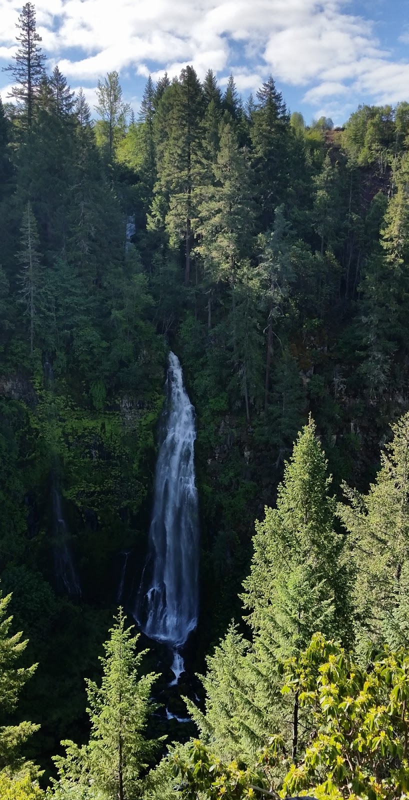
We also saw a waterfall – Multnomah Falls. The area is called “waterfall alley”. We only stopped to see this one.

 
 When we got near Portland, we drove away from the river, to visit Oregon City. This is the official end of the Oregon Trail. We plan to find out more about the Oregon Trail, and its importance to the development of the US, later on our trip. But we decided to stop here, since we were so close.


On the way back to the campgrounds, we drove on the north side of the river – in Washington state. And near the campground, we found a small scenic road, where there were some nice views of the river and cliffs.


With all of the trees in Oregon, we are in logging country. We have seen a number of trucks. Finally got a picture of one.

In Oregon we ran into a very unusual thing at the gas stations (tankstationer). The first time we stopped for gas, there were people pumping for us. Nice service, we thought. Well, it happened again the next time, and the next time…
It turned out that it is the law in Oregon that you cannot pump your own gas!! (except for a very few places in certain counties (amter)).  We were at several gas stations with 10-12 pumps, and 2-3 people running around pumping. We also found out that New Jersey has similar laws. (Guess we didn’t get much gas in New Jersey😊)

 
Written by Mary & JJ

May 29 - 2018 The Dalles, Oregon

Tuesday, 29th, we moved from La Pine to The Dalles, Oregon  (170 miles/ 270 km).
On that move we crossed the 25000 miles mark, since we started our trip last fall (efterår).
25000 miles /40000 km is a lot. It is one time around the earth at the Equator (Ækvator).
That hast taken us about 5½ months.
In 60 seconds it looks like this.


When we are on our long transfers we spend some of the time listening to music.
Inspired by our visit to Luckenbach, Texas, we started talking about songs that we know, that mention
cities, states or places we have been to on our trip.


It has been a fun pastime (tidsfordriv) and so far the list looks like this:

City/State/PlaceSongArtist (among others)
Luckenbach, TexasLuckenbach, TexasWaylon Jennings & Willie Nelson
Massachusetts + San FranciscoMassachusettsBee Gees
New York City + The White House + Las VegasOne's on the wayLoretta Lynn
California + New YorkThis Land is Your LandWoody Guthrie
New YorkNew York, New YorkFrank Sinatra / Liza Minnelli
Suwannee River, FloridaSuwannee RiverBing Crosby
Smokey Mountain, TennesseeOn Top of Old SmokeyPete Seeger
Texarkana, Arkansas + LouisianaCotton Fields Back HomeCreedence Clearwater Revival
Tucson, Arizona + CaliforniaGet BackThe Beatles
DetroitDetroit City (I wanna go home)Bobby Bare
TexasYellow Rose of TexasMitch Miller
Chattanooga, TennesseeChattanooga Choo-ChooGlenn Miller
MississippiOl' Man RiverPaul Robeson
West Virginia + Shenandoah RiverTake Me Home, Country RoadsJohn Denver
Washington DCWashington Post MarchUnited States Marine Band
New Orleans + California + KentuckyMe and Bobby McGeeJanis Joplin / Kris Kristofferson
TennesseeMy Tennessee Mountain HomeDolly Parton
GeorgiaGeorgia on my MindWillie Nelson
KentuckyBlue Moon of KentuckyBill Monroe
Bangor, MaineKing of the RoadRoger Miller
Minnesota+TN+TX+ Detroit+New York, Los AngelesGod Bless the USALee Greenwood
Alabama + Birmingham + WatergateSweet Home AlabamaCreedence Clearwater Revival
OklahomaOklahomaGordon MacRae
New YorkNew York State of MindBilly Joel
New Orleans + Mississippi + Gulf of MexicoThe Battle of New OrleansJohnny Horton
TennesseeThe Tennessee WaltzPatti Page
TexasTexas in my Rear View MirrorMac Davis
Texas + Dallas + New York + San Antonio + DetroitTexas when I DieJerry Max Lane
Phoenix + Oklahoma + AlbuquerqueBy the time I get to PhoenixGlenn Campbell
El PasoEl PasoMarty Robbins
Kentucky + DetroitOne Piece at a TimeJohnny Cash
Key Largo + Florida KeysKokomoBeach Boys
Los Angeles + CaliforniaCalifornia DreamingThe Mamas and The Papas
AlabamaWho's Next?Tom Lehrer
Rocky Mountains + ColoradoRocky Mountain HighJohn Denver
Georgia + San Francisco BaySittin' on The Dock of The BayOtis Redding
OklahomaRed Neck MotherJerry Jeff Walker
CaliforniaIt Never Rains in Southern CAAlbert Hammond
CaliforniaCalifornia BlueRoy Orbison
Gatlinburg, TennesseeA Boy Named SueJohnny Cash
San FranciscoSan FranciscoBrødrene Olsen
San Francisco + TennesseeRock N' Roll (I Gave You the ….Mac Davis
Oklahoma + San FranciscoOkie from MuskogeeMerle Haggard
San FranciscoSan FranciscoScott McKenzie
New York City + Los AngelesI Am, I SaidNeil Diamond
San FranciscoI left my heart in San FranciscoTony Bennett
Georgia + AlcatrazIt makes a fellow proud to be ..Tom Lehrer
Route66 + Chicago + Gallup, NM + Flagstaff, AZ +
Barstow,CA + California + Los Angeles
Route 66John Mayer / Disney Cars
Tennessee + Washington DC + Florida + Texas +
The Alamo + Nashville + The White House
The Ballad of Davy CrockettThe Wellingtons

Written by JJ

May 28 - 2018 La Pine, Oregon


Seeing Mt. Lassen and Crater Lake, has sparked our interest in volcanos. There are a lot of national and state sites in Oregon showing volcanic activities, so we decided to see one today (May 28). It is called the Newberry National Volcanic Monument.
Although it was a short move (110 miles/ 175 km), the monument is spread out through a large forest area, run by the National Forest Service. This made it rather tricky to plan the trip. Our campground is close to the southern-most sites (we were driving up from the south), but we were there way too early to check-in. So, we drove about 20 miles/32 km north, and unhooked the trailer at the visitor’s center.
We then drove 1.5 miles/2.5 km south again, to go to the Lava River Cave. The cave is actually a lava tube, that was formed by molten (flydende) lava. Once the lava stopped flowing, the tube remained hollow, forming a cave. It was pretty cool to see (also literally, because it was 42 degrees F/about 5 degrees C😊). Unfortunately, our pictures didn’t turn out very well, because the only light in the cave came from the flashlights people were carrying.

After the cave, we drove out to the Lava Cast Forest (about 9 miles/15 km on a very rough dirt road). Once (about 7000 years ago), a forest grew here. Lava from a volcanic eruption caused the forest to burn. The steam let off by the burning wood cooled the lava around the trunks. Over time the wood rotted, and left molds of the tree trunks – called lava casts. There were lots of them here. There was also a lot of lava, and after so many thousands of years, still very little vegetation.


Next, we drove back to the visitor’s center, where we caught a shuttle bus, that drove us to the top of Lava Butte. This is a cinder cone, formed by hot gas charged lava, that piled up after exploding from underground. The result is a cone shaped hill, with a crater in the middle.


Now it was time to move our trailer to the campground. So, we hooked it up to the car, and headed south again! By this time, we needed a little rest, before we headed out to The Obsidian Flow (about 15 miles/22 km south and east).

Volcanic lava rocks have different appearances, depending on the minerals they are made of, the temperature they are heated to, and where they land. We had seen many basalt rocks – greyish at the Lava Cast Forest, reddish at the Lava Butte. The Obsidian flow had some of these rough and dry-looking rocks, but it also had a lot of obsidian rocks, which are rocks containing a large amount of silica (73% - which is the same amount of silica in window glass). These are glass rocks. They shine, are sharp, and break easily – just like glass. (We have been hearing about the volcano eruption in Hawaii, that the air is dangerous to breath, because it contains small partials of glass. Now we know what they mean.)


Enough volcanos for today. Time for bed😊

Written by Mary

May 27 - 2018 Prospect, Oregon

The main reason for coming to this area was to see Crater Lake. That’s what we did today (Sunday the 27th).
As the name indicates it has to do with a volcano. About 7-8000 years ago Mount Mazama erupted.
The eruption was so strong that the top of the mountain collapsed into the empty lava dome, creating a big hole instead of a mountain top. A 2150-foot (650 m) hole that over the next 700 years filled with water. That created the deepest lake in the US (almost 2000 feet / 600 meter). The only source of water to the lake was, and is, rain and melting snow.
The area gets an average of 500 inches (ca. 13 meter) of snow each year.

WOW!!!!
There is no river or spring running into the lake and nothing running out either.
Because of that, the water is VERY clear and that combined with the depth (dybden) of the lake makes the water blue.
VERY BLUE. As blue as you have ever seen water.

OOO...
UUU...
III...
Because of all the snow, many of the roads around the lake are closed during the winter and most of the spring. We were lucky that they opened 6 miles (ca 10 km) on the western side on Friday. The northern and the eastern sides are still closed because of snow.
One of the only non-blue pictures!
We went there early and once again we managed to beat the crowds. There were long lines waiting to get in by the time we left.

We took hundreds of pictures. As the morning went, the water seemed to be more and more blue and scenery got prettier by the minute, so it was hard not to keep shooting. And it was hard to choose which ones to use on the blog.

Blue!
Bluer!!!
Bluest!!!
No - this is bluest!!!!
And just when you think it can't get any more blue!!!!!!!!!!!!
Written by JJ
Captions (billedtekster) by Mary 😊

May 24 - 2018 Crescent City, CA - May 25-26 - 2018 Prospect, Oregon

Once in a while, even though we are on “vacation”, we have to take time for practical things (small repairs, general maintenance (vedligehold), defrosting the freezer (afrime fryseren) etc. etc.) Thursday, May 24, was such a day.
When the work was done, we went to see the Pacific Ocean for one last time (we won’t see the ocean again until we are back in Denmark). We had planned on spending more time at the beach, while in this area, but the weather has been foggy and grey, so it hasn’t been too nice by the water.
 
 
Crescent City has a nice beach, with big waves. We saw some surfers…

And found sand dollars (en slags søpindsvin).


Crescent City is built close to sea level, on a part of the shoreline, that is very prone to tsunamis. In 1964 the town was almost totally destroyed by 4 tidal waves, caused by an earthquake in Alaska. I found this interesting. We have heard about tsunamis in places like Japan and Thailand, but I had never thought much about them happening in the USA.
I guess Minnesota is too far away from the ocean.

We also went for a last walk in the woods. JJ wanted to go on the walk that I had done alone on Monday.
Once again, we found big trees and peaceful quietness.

This cypress tree is one of the plants that uses a "host" tree to grow on.
I thought this one looked strange, because the "host" (a redwood tree)
was decaying,
leaving the tree way above the ground.
Friday, the 25th we made a short move (135 miles/ 215 km) to Prospect, Oregon.
Pretty non-eventful. It rained most of the day.

Saturday, the 26th, we explored the area. We are staying at a campground, that is in the middle of a wilderness area. There are lots of creeks, hills, woods, rocks, and a river. We drove out to see a couple of waterfalls, a river, and “Lookout Mountain”. All very nice.


I thought there was going to be a Memorial Day parade in town today. (Memorial Day er en national dag, hvor amerikanerne minder alle soldater og den indsats, de har gjort for deres land. Selve dagen er den sidste mandag i maj. Det er en af de få 3-day weekender amerikanerne har.) Prospect is a small town of about 600 people, so we thought it would be fun to see a small-town celebration. Turned out that it was Prospect, Pennsylvania that was having the parade. I guess I was quite a bit off

In the evening, the campground hosted a weeny roast (pølser). They had a nice fire and a woman singing songs from the 60's and 70's. We went for a couple of hours, talked to some new people, and had a nice time.

 
Written by Mary